Kohlbornstein

Entre na sua conta

AroundUs é um mapa colaborativo de lugares interessantes, construído por exploradores curiosos como você. Ele cresce com cada avaliação, história e foto que você compartilha.
Conecte-se para salvar seus lugares favoritos, contribuir com locais e criar rotas personalizadas.
Ao continuar, você aceita nossos Termos e Condições e nossa Política de Privacidade

Kohlbornstein

Adicionar à coleção
Mapa
Sugerir uma alteração
Partilhar

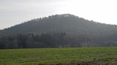
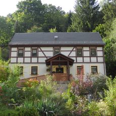
Kohlbornstein, Cume em Gohrisch, Alemanha.

O Kohlbornstein eleva-se 378 metros acima do nível do mar na Suíça Saxônica, apresentando formações de arenito das camadas geológicas Postelwitz e Schrammstein.

Em 1884, a Associação de Montanha da Suíça Saxônica construiu uma trilha até o cume, seguida por uma visita do Rei Alberto e da Rainha Carola em 1886.

A trilha Malerweg passa ao norte do Kohlbornstein, conectando as vilas de Kleinhennersdorf e Krippen através de caminhos marcados nas Montanhas de Arenito do Elba.

Os caminhantes podem acessar o cume exclusivamente pelo sudoeste, com um percurso de 11.3 quilômetros que requer aproximadamente 3 horas e 40 minutos.

O nome Kohlbornstein deriva da fonte Kohlborn localizada na base norte do pico, onde a água emerge das formações de arenito.

Localização: Gohrisch

Coordenadas GPS: 50.89800,14.15474

Última atualização: 17 de março de 2025 às 16:48

A vista
A vista
QRCode
Ao redor deste lugar
Mostrar o mapa completo
Reinhardtsdorf Sandstone
Germany

Reinhardtsdorf Sandstone

1.1 km
Dorfkirche Krippen
Germany

Dorfkirche Krippen

1.3 km
Bogenbrücke über den Krippenbach Friedrich-Gottlob-Keller-Straße 71 (bei)
Germany

Bogenbrücke über den Krippenbach Friedrich-Gottlob-Keller-Straße 71 (bei)

981 m
Schule Friedrich-Gottlob-Keller-Straße 39
Germany

Schule Friedrich-Gottlob-Keller-Straße 39

1.5 km
Friedrich-Gottlob-Keller-Straße 78
Germany

Friedrich-Gottlob-Keller-Straße 78

976 m
Bogenbrücke über den Krippenbach Friedrich-Gottlob-Keller-Straße 63 (bei)
Germany

Bogenbrücke über den Krippenbach Friedrich-Gottlob-Keller-Straße 63 (bei)

1.1 km
Alte Schule
Germany

Alte Schule

1.3 km
Wohnhaus des Friedrich Gottlob Keller Friedrich-Gottlob-Keller-Straße 76
Germany

Wohnhaus des Friedrich Gottlob Keller Friedrich-Gottlob-Keller-Straße 76

961 m
Berghangweg 17
Germany

Berghangweg 17

1.5 km
Postgebäude Friedrich-Gottlob-Keller-Straße 56
Germany

Postgebäude Friedrich-Gottlob-Keller-Straße 56

1.2 km
Wohnhaus Friedrich-Gottlob-Keller-Straße 79
Germany

Wohnhaus Friedrich-Gottlob-Keller-Straße 79

982 m
Wohnhaus Friedrich-Gottlob-Keller-Straße 27
Germany

Wohnhaus Friedrich-Gottlob-Keller-Straße 27

1.5 km
Liethenmühle
Germany

Liethenmühle

604 m
Wohnhaus Friedrich-Gottlob-Keller-Straße 64
Germany

Wohnhaus Friedrich-Gottlob-Keller-Straße 64

1.1 km
Wohnhaus Friedrich-Gottlob-Keller-Straße 48
Germany

Wohnhaus Friedrich-Gottlob-Keller-Straße 48

1.3 km
Sachgesamtheit Ev. Pfarrkirche und Kirchhof Krippen mit folgenden Einzeldenkmalen: neoromanische Saalkirche mit Südwestturm, Kriegerdenkmal für die Gefallenen des Ersten Weltkrieges, Grabstätte F.G. Keller und Grufthaus (siehe Einzeldenkmalliste -
Germany

Sachgesamtheit Ev. Pfarrkirche und Kirchhof Krippen mit folgenden Einzeldenkmalen: neoromanische Saalkirche mit Südwestturm, Kriegerdenkmal für die Gefallenen des Ersten Weltkrieges, Grabstätte F.G. Keller und Grufthaus (siehe Einzeldenkmalliste -

1.2 km
Ehemaliges Armenhaus Friedrich-Gottlob-Keller-Straße 66
Germany

Ehemaliges Armenhaus Friedrich-Gottlob-Keller-Straße 66

1.1 km
Wohnhaus über winkligem Grundriss Friedrich-Gottlob-Keller-Straße 21
Germany

Wohnhaus über winkligem Grundriss Friedrich-Gottlob-Keller-Straße 21

1.6 km
Wohnhaus Friedrich-Gottlob-Keller-Straße 71
Germany

Wohnhaus Friedrich-Gottlob-Keller-Straße 71

993 m
Wohnhaus Friedrich-Gottlob-Keller-Straße 68
Germany

Wohnhaus Friedrich-Gottlob-Keller-Straße 68

971 m
Wohnhaus Friedrich-Gottlob-Keller-Straße 31
Germany

Wohnhaus Friedrich-Gottlob-Keller-Straße 31

1.5 km
Schinkemühle Krippen
Germany

Schinkemühle Krippen

958 m
Wohnhaus in offener Bebauung Friedrich-Gottlob-Keller-Straße 10
Germany

Wohnhaus in offener Bebauung Friedrich-Gottlob-Keller-Straße 10

1.7 km
Wohnhaus in offener Bebauung, mit Einfriedung Friedrich-Gottlob-Keller-Straße 8
Germany

Wohnhaus in offener Bebauung, mit Einfriedung Friedrich-Gottlob-Keller-Straße 8

1.7 km
Wohnhaus in offener Bebauung Friedrich-Gottlob-Keller-Straße 73
Germany

Wohnhaus in offener Bebauung Friedrich-Gottlob-Keller-Straße 73

998 m
Wohnhaus in offener Bebauung mit Treppenaufgang Friedrich-Gottlob-Keller-Straße 9
Germany

Wohnhaus in offener Bebauung mit Treppenaufgang Friedrich-Gottlob-Keller-Straße 9

1.7 km
Wohnhaus Kleinhennersdorfer Straße 2
Germany

Wohnhaus Kleinhennersdorfer Straße 2

954 m
Wohnhaus in offener Bebauung Kleinhennersdorfer Straße 7
Germany

Wohnhaus in offener Bebauung Kleinhennersdorfer Straße 7

822 m
Mostrar o mapa completo

Avaliações

Visitou este local? Toque nas estrelas para avaliá-lo e partilhar a sua experiência ou fotos com a comunidade! Experimente agora! Você pode cancelar a qualquer momento.

Kohlbornstein - Cume em Gohrisch, Alemanha é fornecido por Around Us (pt.aroundus.com). As imagens e os textos são derivados do projeto Wikimedia sob uma licença Creative Commons. Você é permitido copiar, distribuir e modificar cópias desta página, sob as condições estabelecidas pela licença, desde que esta nota esteja claramente visível.

Encontra tesouros escondidos em cada aventura!

De pequenos cafés cheios de charme a miradouros secretos, foge das multidões e descobre lugares que têm mesmo a tua cara. A nossa app torna tudo simples: pesquisa por voz, filtros espertos, rotas otimizadas e dicas genuínas de viajantes do mundo inteiro. Descarrega já para viveres a aventura no teu telemóvel!

Around Us App Screenshot

Uma nova abordagem para descobrir o turismo

Le Figaro

Todos os lugares que valem a pena explorar

France Info

Um passeio sob medida em apenas alguns cliques

20 Minutes